world.png
Land use/cover data of Mongolia with spatial resolution of 30m(2010)
/static/upload/b0/b0c56768-3c93-11e8-b2c5-00163e0618d6_m.jpg

Release time:2015-11-29

Browsing times: 708

Tag:

Data Abstract

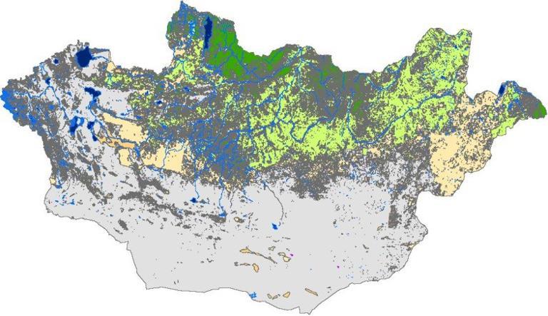
This dateset provides land use/cover data of Mongolia, with the spatial resolution of 30m, using the Albers projection, based on WGS-1984 geographic coordinate system. This data was interpreted on the basis of Landsat TM/etm+ remote sensing image and has 9 first classes including forest land, grassland, wet land, cultivated land, water, tundra,construction land, bare land and snow.The classfication accuracy is 82.26% and can be used for the study of land use/cover change in Mongolia, land management, planning and design of urban city.

Contributor
2014-09-13
Dataset Size
374784 kb
Purpose
used for the study of land use/cover change in Mongolia, land management, planning and design of urban city.
License
Institute of Geographic Sciences and Natural Resources Research, Chinese Academy of Sciences
Scale
spatial resolution of 30m
Production Unit
Institute of Geographic Sciences and Natural Resources Research, Chinese Academy of Sciences
Data Quality
complete and reliable
Contributor Address
A11 Datun Road, Chaoyang District, Beijing
Contributor Postcode
100101
Contributor Phone
010-64889048-8006
Contributor Email
ikcest-drr@lreis.ac.cn
Responsible Name
WDC RRE Working Team
RespInst Name
Institute of Geographic Sciences and Natural Resources Research, CAS.
RespInst Address
11 A, Datun Road, Chaoyang District, Beijing, 100101, China.
RespInst Postcode
100101
RespInst Phone
+86-10-64889048-8006
RespInst Email
wdc-rre(at)lreis.ac.cn
RespInst Fax
+86-10-64889048
RespInst Homepage
http://english.igsnrr.cas.cn/


    Sign in for comments!
Comment list (0)

Information evaluation
Most attention
Recent articles
All rights reserved. © World Data Center for Renewable Resources and Environment, since 2014.