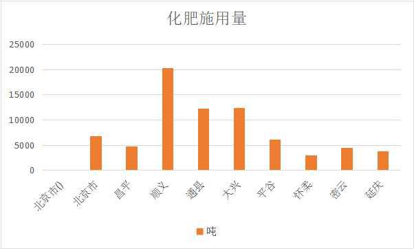

I. Dataset content features
i. Abstract
The datasets are socioeconomic data of China, which mainly Population by county, rural output value by county, rural electricity consumption, area of agricultural land, output of crops, total power of agricultural machinery, area sown by crops, total output of meat, the gross annual value of counties in1985-1999. They are collected and organized by Institute of Geographic Sciences and Natural Resources Research, Chinese Academy of Sciences, and include Fertilizer consumption by county(1985,1987,1988,1989,1990,1991),county rural output(1985,1987,1988,1989,1990,1991)There is totally 98 files in .xlsx format in county level. They can be used to study on nation economic development, sustainable development of Chinese counties .
ii. Elements (content fields)
The datasets are named as “Statistics on rural economy in China's counties from 1985 to 1999”, which include 98 data files. There are mainly 9 data name for different years (1985, 1987, 1988, 1989, 1990, 1991,1993,1994,1995,1996,1997,1998,1999) and they are described as table 1.
| Data name | Item(field) | Field name in chinese | Field measure unit | Field code description | Remarks |
|---|---|---|---|---|---|
| Statistics on rural economy in China's counties from 1985 to 1999 | Fertilizer amount by county | 分县化肥量 | Ton | ||
| Rural output | Total purchases of social agricultural and sideline products, gross output value of rural society, total agricultural output value, net agricultural output value | 社会农副产品收购总额、农村社会总产值、农业总产值、农业净产值 | Ten thousand yuan | ||
| Rural power consumption | Electricity consumption in rural areas | 农村用电量 | Ten thousand kilowatt/hour | ||
| County agricultural machinery power | Agricultural machinery power agricultural output value. | 农业机械总动力 | Wanwatt | ||
| County agricultural land area | Farmland area Farmland area Effective | 耕地面积机耕面积有效灌溉面积 | hectares | ||
| Sown area | total sowing area of crop,Grain sown area,Cotton sown area,Oil plants sown area | 农作物总播种面积,粮食播种面积,棉花播种面积,油料播种面积 | Ha | ||
| Crop yield | Total grain output,Total cotton output,Total oil production | 粮食总产量,棉花总产量, 油料总产量 | Ton | ||
| Meat yield | total production of pork, beef and mutton | 猪牛羊肉总产量 | Ton | ||
| Rural population | rural population of county | 乡村人口 | Ten thousand people | ||
| Basic situation of grassland resources | Total population, total land area, reserve area of artificial grassland, natural grassland area, the proportion of natural grassland, natural area ordering, natural grassland available area, the theoretical stock capacity of natural grassland | 总人口,土地总面积,人工种草保留面积,天草地面积,天然草地占当地土地总面积,天然草地面积排序,天然草地可利用面积天然草地理论载畜量 | Ten thousand people, km2,ha, sheep/year |
iii. Temporal cover Time of the dataset include1985,1987, 1988,1989,1990,1991,1993,1994,1995,1997,1999 iv. Spatial cover The covered area of the dataset includes total counties and districts of China. For example in Beijing, there are 8 districts named Changping, Shunyi, Tongxian, Daxing, Pinggu, Huairou, Miyun, and Yanqing. II. Subject/industry scope of dataset/atlas i. Subject scope Earth Science, environmental sciences, regional sustainable development, geography. ii. Industry scope Urban and rural development services, rural construction and planning. iii. Other classifications (optional)
III. Accuracy of dataset/atlas i. Time frequency County level. ii. Spatial reference, accuracy, and granularity The dataset is test data without spatial reference, the minimal granularity of the dataset is a county. IV. Dataset/atlas storage management i. Data quantity The volume of the dataset is 5.10MB. ii. Type format The dataset is stored in hard disk with a format of Microsoft Excel (.xlsx). iii. Update management Unscheduled update. V. Quality control of the dataset/atlas i. Data sources (condition selection) Social statistics ii. Methods of the data acquisition and processing (condition selection) The data comes from remote sensing images, and the data is processed through ArcGIS, and the data is exported and presented using EXCEL. VI. Sharing and usage method of the dataset/atlas i. Sharing methods and restrictions Full and open sharing. ii. Contact information of the sharing service (condition selection) Online link address: Contact Information for Service: Name: Yuan Yuelei Address:11A, Datun Road, Chaoyang District, Beijing, 100101, China, Institute of Geographic Sciences and Natural Resources Research, CAS. Zip Code:100101 E-mail: wdc-rre@lreis.ac.cn iii. Conditions and methods of usage The dataset can be read by Microsoft Office software. VII. Intellectual property rights of the dataset/atlas i. Property rights (optional) Intellectual property of the dataset belonged to Institute of Geographic Sciences and Natural Resources Research, CAS. ii. Reference method of the dataset/atlas Socioeconomic data of China, Institute of Geographic Sciences and Natural Resources Research, Chinese Academy of Sciences [Establishment organization], 2003. World Data Center for Renewable Resources and Environment [Communication agency], 2017-3-4. iii. Usage contacts of the datasets/atlas Name: Yuan Yuelei Address:11A, Datun Road, Chaoyang District, Beijing, 100101, China, Institute of Geographic Sciences and Natural Resources Research, CAS. Zip Code:100101 E-mail: wdc-rre@lreis.ac.cn VIII. Others (optional) In addition to the above, other information must also be explained.
Data documentation author information |
|||
|---|---|---|---|
| Data documentation author | Bian Lingling | Update time | 2017-3-4 |
| Organization | Institute of Geographic Sciences and Natural Resources Research, CAS | ||
| Contact information | |||
| Address | 11A, Datun Road, Chaoyang District, Beijing, 100101, China | Postcode | 100101 |
| Telephone | +8615689311687 | bianll@lreis.ac.cn | |