world.png
The drought level database of cropland in Belt and Road Area from 2001 to 2013

Data Abstract

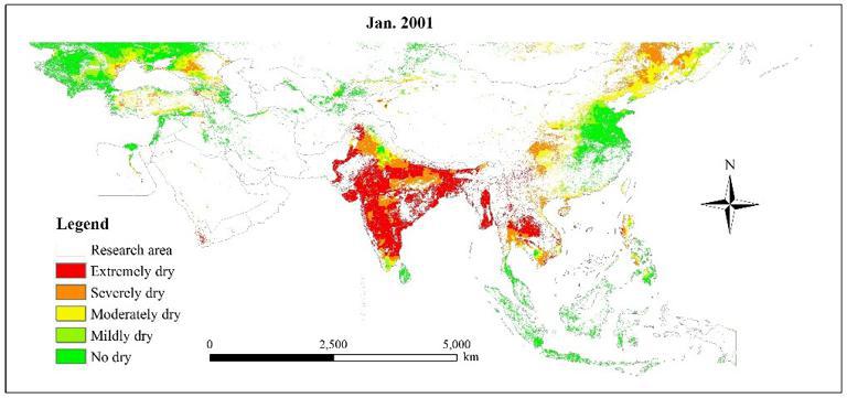
Based on the Tropical Rainfall Measurement Satellite (TRMM) 3B43 precipitation data, we used the Precipitation Abnormity Percentage drought model to study the monthly spatio-temporal distribution of drought in south region of N50° of OBOR area from 2001 to 2013. Yearly spatio-temporal distribution from 2001 to 2013 of cropland in OBOR area was extracted based on the MODIS MCD12Q1 dataset and there were 156 monthly drought levels in the cropland region according to the overlaying of drought and agricultural land layers.

Format
Grid
Time begin
2001-01-01
Time end
2013-01-01
Contributor
2017-03-10
Organization
Institute of Geographic Science and Natural Resouces Research, CAS
Date publication
2017-03-10
Dataset Size
2222981.12 kb
Purpose
Scientific research, teaching, and government decision-making
Production Unit
Institute of Geographic Sciences and Resources Research, Chinese Academy of Science Institute of Geographic Sciences and Resources Research, Chinese Academy of Science
Data Quality
This data is complete and reliable.
Contributor Address
No11. First area of Datun Road,District of Chaoyang,Peking City, China
Contributor Postcode
100101
Contributor Phone
010-64889048-8006
Contributor Email
ikcest-drr@lreis.ac.cn
Contributor Homepage
http://www.igsnrr.ac.cn
Responsible Name
WDC RRE Working Team
RespInst Name
Institute of Geographic Sciences and Natural Resources Research, CAS.
RespInst Address
11 A, Datun Road, Chaoyang District, Beijing, 100101, China.
RespInst Postcode
100101
RespInst Phone
+86-10-64889048-8006
RespInst Email
wdc-rre(at)lreis.ac.cn
RespInst Fax
+86-10-64889048
RespInst Homepage
http://english.igsnrr.cas.cn/


    Sign in for comments!
Comment list (0)

Information evaluation
Most attention
Recent articles
All rights reserved. © World Data Center for Renewable Resources and Environment, since 2014.