
The purpose of this data set is to study the geographic environment related data of Sanjiang plain in China, and to understand the landform types, vegetation types, soil types and other related soil indexes of Sanjiang plain.
The time range of this data set: 2005
The service object of this dataset is students and researchers engaged in natural geography.
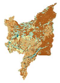
The data type of this data set is GeoTiff, which belongs to natural geography discipline. Data collection range is related to survey data of Sanjiang plain marsh wetland geographic environment. The spatial reference standard (projection and coordinate system) is Albers, and the spatial granularity is 250m.
The data originate from the results of a number of work compiled by the Institute of northeast geography and Agro ecology of the Chinese Academy of Sciences on land use and other geographic environmental data. After remote sensing interpretation and data sorting, the data of the Sanjiang plain (type, attribute), soil (type, physicochemical property), vegetation type and so on, including soil thickness, A layer soil thickness, organic matter content, pH value and soil bulk density, etc. Among them, the soil types include dark brown soil, white pulp dark brown soil, meadow dark brown soil, dark brown soil, dark brown soil, white pulp soil, meadow white pulp, dive soil, black soil, meadow black soil, white soil, meadow soil, lime meadow soil, meadow soil, meadow, meadow, meadow, meadow, meadow, meadow, meadow, meadow, and meadow. Soil type submergence paddy soil, white pulp soil type submergence paddy soil, alluvial soil type submergence paddy soil, black soil type submergence paddy soil, marsh soil type submergence paddy soil, marsh soil, peat swamp soil, meadow marsh soil, alluvial soil, low peat soil.
The data table is raster data, and the data processing method is the remote sensing interpretation of the result topographic map. The specific processing method is to get the topographic map processed by software ArcMap, and get raster data. Then the data is combined with the data, and the final compilation of the cost data sets, including landform type, vegetation type, soil type, soil thickness, A layer soil thickness, organic matter content, pH value and soil bulk density and so on.
Through the survey of marsh wetland in China, through remote sensing interpretation and data sorting, according to standard standard, GIS data files are registered according to different scales to meet the quality requirements. Self check, check the other people's core. The content of the check is to see if there are any missing blocks in the relief map. If there are missing blocks, continue to look up old maps and re map them.
 Northeast Institute of Geography and Agroecology, Chinese Academy of Sciences